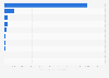
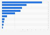
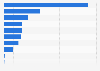
| Characteristic | Percentage of land area protected |
|---|---|
| - | - |
| - | - |
| - | - |
| - | - |
| - | - |
| - | - |
| - | - |
| - | - |
| - | - |
| - | - |
| - | - |
The chart is not accessible to screen readers. Please switch to the table view to access the data.
February 2016
Asia
2014
Definition: The terrestial areas protected refers to the total land area dedicated to the protection and maintenance of biological diversity, and of natural and associated cultural resources, and managed through legal or other effective means. Only protected areas that are nationally designated are included in this indicator. This indicator is expressed as a percentage of the surface area.
Aggregation: Weighted averages using surface area as weight.
Source: MDG Indicators Database. The data source is the World Database on Protected Areas (WDPA), the most comprehensive global dataset on marine and terrestrial protected areas available. WDPA is a joint product of UNEP and IUCN, prepared by UNEP-WCMC and the IUCN World Commission on Protected Areas working with governments, the secretariats of Multilateral Environmental Agreements and collaborating non-governmental organizations (NGOs). Data are reported by countries to WDPA. Quality control criteria are applied to ensure consistency and comparability of WDPA data. New data are validated at UNEP-WCMC through a number of tools and translated into the standard WDPA data structure. Discrepancies between WDPA data and new data are resolved in communication with data providers. Processed data is fully integrated into the published WDPA.
Data obtained: 18 August 2015