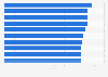
| Characteristic | Magnitude |
|---|---|
| Dodecanese (1956) | 7.7 |
| Aegean Sea (Lesbos, Skiros, 1981) | 7.5 |
| Lixouri-Argostoli (Kephallenia, 1953) | 7.2 |
| Aegean Sea (St. Eustratios, 1968) | 7.2 |
| Ionian Sea (1983) | 7.2 |
| Greece (1965) | 7.1 |
| Aegean Sea (1983) | 7 |
| Sophades (Karditsa, 1954) | 7 |
| Greece (1954) | 7 |
| Stephanovikion-Velestnon (Magnesia, 1957) | 7 |
| Greece, Turkey (2014) | 6.9 |
| Ionian Sea (Zakynthos, Strofades, 2018) | 6.8 |
| Asprogerakas (Kephallenia, 1953) | 6.8 |
| S (1962) | 6.8 |
| Aegean Sea (1956) | 6.8 |
| Southern (2006) | 6.7 |
| Athens-Eastern Gulf Of Corinth (1981) | 6.7 |
| Crete (2020) | 6.6 |
| Grevena-Kozani, Thessaloniki, Yugoslavia (1995) | 6.6 |
| Ionian Sea, Amalias, Gargalianoi, Kalamai (1997) | 6.6 |
| Crete (Chania, 2013) | 6.6 |
The chart is not accessible to screen readers. Please switch to the table view to access the data.
Loading statistic...
Download
Source
More information
Region
Greece
Survey time period
1950 to 2025
Supplementary notes
Magnitude is measured based on the Richter scale.
Includes the earthquakes in and around Greece that match the following criteria: damage of approximately one million U.S. dollars or more, 10 or more deaths, magnitude 7.5 or greater, Modified Mercalli Intensity X or greater, or the earthquake generated a tsunami.
Citation formats